


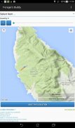
Forager's Buddy - GPS foraging
Beschreibung von Forager's Buddy - GPS foraging
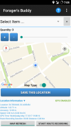
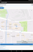
Forager's Buddy ist eine kostenlose Anwendung für Android-Smartphones und -Tablets, die Benutzern helfen soll, alle bemerkenswerten Orte auf der Karte zu markieren, an denen sie verschiedene Arten von Wildfutterressourcen finden können (unter Verwendung des GPS-Moduls des Geräts).
Sie können diese Nahrungssuche-App bei verschiedenen Outdoor-Aktivitäten wie Wildkräuter-/Pilzsammeln, Jagen, Angeln, Camping, Wandern usw. verwenden
Wichtig: Android 10+ hat neue Standortberechtigungseinstellungen. Damit die Forager's Buddy-Routenaufzeichnung ordnungsgemäß funktioniert, müssen Sie die Option "Immer zulassen" auswählen (unter App-Info -> App-Berechtigungen -> Standort).
Forager’s Buddy Kurzanleitung [PDF] – https://bit.ly/3usgDt6
Forager’s Buddy Quick Tutorial 1 [Video] – https://youtu.be/jWCD6dVO3II
Forager’s Buddy Quick Tutorial 2 [Video] – https://youtu.be/s9DHd6lT160
Forager’s Buddy Quick Tutorial 3 [Video] – https://youtu.be/2TmSqWIxSC0
Forager’s Buddy Quick Tutorial 4 [Video] – https://youtu.be/f-jYRJls89Q
Forager’s Buddy Quick Tutorial 5 [Video] – https://youtu.be/Ssx1a3Y-C1I
Zögern Sie nicht, uns über die Änderungen zu informieren, die Sie in Forager's Buddy sehen möchten.
Funktionen (kostenlose Ausgabe):
1. Auswahl zwischen imperialen und metrischen Systemeinheiten
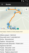
2. Routenaufzeichnung und -anzeige (Exportieren der Route als .kml-Dateiformat)**. Es besteht die Möglichkeit, Orte in der Nähe anzuzeigen und .kml-Routendateien in das .gpx-Format zu konvertieren
3. Exportieren und Importieren von Daten als CSV.
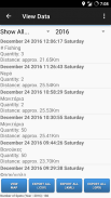
4. Datenfilterung.
5. Hängen Sie ein Foto an einen Ort an
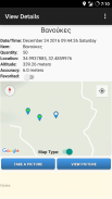
6. Anzeigen der ungefähren Entfernung jedes Elements von der aktuellen Position des Benutzers.
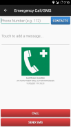
7. Notruf und SMS (Sendet eine SMS mit dem letzten bekannten Standort des Benutzers und dem Batteriestatus des Geräts).
8. Favoriten.
9. Teilen des Artikelstandorts (z. B. per E-Mail oder SMS).
10. Aktuelle Standortfreigabe (z. B. per E-Mail oder SMS).
11. CSV-Dateifreigabe (z. B. per E-Mail oder Bluetooth).
12. KML-Routen-Filesharing (z. B. per E-Mail oder Bluetooth).
13. Benutzerdefinierte Standorte. Benutzer können benutzerdefinierte Orte vom Hauptbildschirm aus speichern, indem sie lange auf den gewünschten Ort auf der Karte klicken.
14. Automatische Sicherung (Export in .csv) jedes Mal, wenn der Benutzer Änderungen vornimmt.
15. Dunkles Thema
16. Sie können leicht finden, was Sie im aktuellen Monat suchen (basierend auf Ihren bisherigen Erkenntnissen)
Funktionen (Pro-Edition):
1. Alle Funktionen der kostenlosen Edition / werbefrei
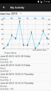
2. Meine Aktivität. Grafische Darstellung der monatlich gesammelten Artikel.
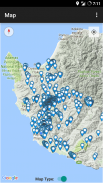
3. Radar. Zeigt eine Karte und eine Liste der vom Benutzer gesammelten Gegenstände an. Die Karte wird alle 3 Sekunden aktualisiert. Die Reichweite des Radars ist einstellbar: 0 – 1000 Meter.
4. Benutzerdefinierte Standorte. Benutzer können benutzerdefinierte Orte auf dem Bildschirm "Karte anzeigen" speichern, indem sie lange auf den gewünschten Ort auf der Karte klicken.
5. Aktuelle Wetterbedingungen für den aktuellen und gespeicherten Standort.
6. Exportieren Sie Daten in das .kml-Dateiformat (Benutzer, die Tools wie Google My Maps verwenden, können diese Funktion verwenden, um benutzerdefinierte Karten für ihre Websites oder Blogs zu erstellen).**
7. Exportieren Sie Daten in das Dateiformat .gpx.
8. Notizen durchsuchen.
9. Erstellen Sie Erinnerungen im Kalender.
10. Orte in der Nähe anzeigen (auf dem Bildschirm Artikeldetails anzeigen).
Von Forager's Buddy exportierte Dateien (.csv, .gpx und .kml) können einfach in GIS (Geographic Information System)-Software (wie QGIS) importiert werden, um weitere geografische Datenanalysen durchzuführen.
Berechtigungen:
1. Kontakte/Telefon - Für die Funktion „Notruf/SMS“. Benutzer können einen Kontakt auswählen, um im Notfall anzurufen oder eine SMS zu senden (es sendet auch den letzten bekannten Standort des Benutzers und den Batteriestatus des Geräts).
2. Standort - Aus offensichtlichen Gründen :)
3. Speicher – Zum Speichern von exportierten Dateien wie: Spots (.kml, .csv), Routen (.kml) und Fotos
Sind Sie Blogger oder Journalist? Fordern Sie einen Google Play Promo-Code an, um die Forager's Buddy PRO Edition zu testen! https://goo.gl/ufpt7M
** KML ist ein Dateiformat, das verwendet wird, um geografische Daten in einem Earth-Browser wie Google Earth, Google Maps und Google Maps für Handys anzuzeigen.
Forager's Buddy - GPS foraging – Version 3.8.2
(02-08-2024)Forager's Buddy - GPS foraging – APK Informationen
APK Version: 3.8.2Paket: com.gh_its.foragersbuddyNeueste Version von Forager's Buddy - GPS foraging
Weitere Versionen


Apps in derselben Kategorie

Das könnte dir auch gefallen...


